
The Forgotten Southwest Face via Dir Gol, Arkari Valley
Inzimam Ul Haq
In few inhabited places on earth does a 7700-meter giant dominate daily life. In Chitral, that giant is Tirich Mir. No matter where you turn, it watches over you – the crown of the Hindukush, standing in all its beauty and might. This massive massif contains 6 peaks above 7000m, with Tirich Mir Main standing at 7708m, first conquered by the Norwegian team in 1950.
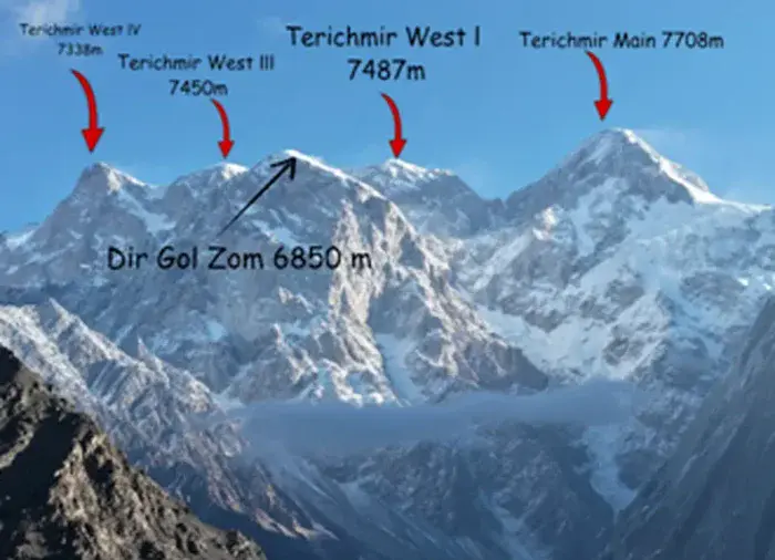
Professor Arne Naess, the leader of that first Norwegian expedition, described the mountain beautifully:[i]“Tirich Mir is the name not only of a mountain with two main peaks, but also of a mountain massif. The massif resembles an octopus, the head of which comprises the twin peaks of 7,700m and 7,692m, while the tapering tentacles are mountain ridges with peaks of from 7,487m, 7,338m, 7,056m, 6,777m and right down to 4,572m. If we include the long ridges leading up to the twin summits, the Tirich Mir Massif covers about one hundred square miles.”
This mountain massif lies in what Adolf Diemberger referred to as the High Hindukush, or the Pakistani Hindukush, [ii]in Chitral District of KPK.The glacial meltwater running through the chest of this mountain has created a number of beautiful villages and their pastoral lands, ultimately defining its approach routes according to its faces. Its North face lies in the Terich Valley, its South-East and South faces in the Owir Valley, and its South-West face in the ArkariValley. Onall faces, a gigantic glacier system exists, making its approach difficult, as is the case with every big mountain.
There is a very long history of exploratory and climbing expeditions to this mountain, with more than 13 successful ascents to date, which I will not detail individually here as it is not the main focus of this article.
Terich Corcodia
I began my reconnaissance of this massif via its North face, through the Terich Valley, in July 2025. This valley, locally called Atahk, is not only the approach to Tirich Mir, but also to the gigantic Istor-o-Nal Peak and Noshaq Peak, both above 7,000m. The glaciers creeping down from all these mountains meet here at Terich Concordia, forming a rare amphitheatre of ice and rock.
Describing it, British explorer and writer R. C. F. Schomberg writes: “There can be few places in the world where such magnificent scenery can be so easily approached and enjoyed.”
The route to base camp is organized and divided into three camps, as it has been regularly used for mountaineering expeditions. Over glaciers, moraines, and boulders, you walk up to 4,720m, and from here onward the mountaineering team begins its journey to Tirich Mir.
The drawback for general trekkers who want to see the mountain is that at this point its view is blocked by the wall of many 6,000m peaks, and you cannot see it from the base camp. But as I mentioned earlier, the importance of this valley cannot be undermined, as it is the easiest way to attempt Mt. Tirich Mir and serves as the base camp for the rest of the 7,000m peaks. That is why it is called the conventional route for climbing Tirich Mir.
North Barum Glacier Owir Valley
In the same month, I got the opportunity to visit the South face via the Owir Valley, at Brum Gol. In comparison to the Terich route, the commute to base camp is shorter, and one long march can bring you to the mouth and confluence of the North Barum and South Barum Glaciers. It holds real historical significance, as the first Norwegian expedition attempted the South face via this valley.[iv] Again, for general trekkers, the view of the massif is blocked, and it can only be seen if you traverse the glacier and set foot on the South Barum Glacier, which is again a mountaineering venture requiring safety equipment.
A year later, in August 2026, I, along with friends from our local trekking club[v], explored a pass that connects Karimabad to the Arkari Valley. After crossing the 5,120m-high pass, we descended to Dir Gol, a tributary of the ArkariRiver, and camped at their pastoral land called “MuxhuGhari”.
The South West Wall Arkari
The next morning dawned bright and sunny, and we saw the southwest wall quite clearly from top to bottom, looking quite approachable. When we asked the locals, they said they had never seen an organized party here, but they had heard from their elders that foreigners came here a long time ago and that one party had also climbed Tirich Mir from here. The wall is sheer and vertical, with hanging seracs that make climbing it seem impossible.
Upon returning home, I researched the route but could not find a single report of anyone climbing this face. A few reports mention teams coming up to this valley, but they ultimately diverted their route to Owir, calling it impossible. Taking this as a challenge, I planned an exploratory visit to this forgotten land and asked my friend Rameez, a drone expert, to capture the wall. To cover expenses and bring people to this valley for the first time, I posted about this exploratory visit as an open expedition. It drew an encouraging response, with 11 participants from different cities across Pakistan joining in, including 6 women. Tania, a young woman explorer from Belarus, also joined the team.
As per the 4-day plan, the team arrived in the Arkari Valley on October 17th. The locals were both curious and happy to see an organized tourist team for the very first time. The team then marched to the pastoral land of Muxhu Ghari on the 18th, and on the 19th began the march towards base camp. Six people, including a local guide and two women — Aeman from Islamabad and Tania from Belarus — managed to reach the base camp, located at 4,288m (36°13’24.65″N 71°47’29.65″E).
The base camp is a flat patch of land on a small ridge, but it offers a magnificent view of DirgolZom, Tirich Mir Main Peak, and the glacier flowing down from the summit to the base. To our surprise, we found graffiti on a stone that read: “Ishikawa Japan Expedition 10 July 1971 Success Mt Tirich Mir”. We were thrilled to see it, and upon researching later, we found that a Japanese team had indeed climbed it from the Dir Gol side. This discovery made our mission of establishing the base camp a success — or you could say that we rediscovered it.
The route is quite accessible and, with its clear views, offers a beautiful two-day trek to base camp for mild trekkers, both national and international. From a mountaineering perspective, it is a tough route to follow, but we are hopeful that some passionate mountaineers will definitely choose this challenging path, making this valley an adventure ground for tourism.
(The writer is an expedition guide and mountain researcher based in Chitral and can be reached at: Inzimam.eco@gmail.com).
Related:
Two Japanese climbers scale Terichmir